There is a moment, somewhere between Paros and Naxos, with the Meltemi pushing 22 knots on your beam and the hull of your boat cutting through water the colour of hammered tin, when the Cyclades stops being a destination and becomes an education.
These 220 islands, scattered across the central Aegean like a dropped handful of white dice, have shaped mariners and navigators for over 3,000 years. Odysseus navigated these waters. The Venetians built their fortified harbours here. Today, they shape you.
This guide is not a brochure. It is a navigation masterclass, the kind you would receive from a seasoned Aegean captain who has anchored in every bay worth anchoring in, been caught out by every wind that catches out the careless, and learned, slowly, how to read this sea.
Understanding the Cyclades: Geography and Why It Matters
The Cyclades take their name from the ancient Greek word kyklos, circle. The islands form a rough ring around the sacred island of Delos, which was long considered the centre of the ancient maritime world.
Geographically, this matters for two reasons:
- There is no natural shelter from the north. The Aegean is a long, enclosed sea oriented north-to-south. When the Meltemi blows, and it will blow, it has a 500km fetch before it reaches you.
- The islands are closely spaced. Unlike offshore blue-water sailing, you are rarely more than 15–25 nautical miles from the next landfall. This rewards careful pilotage over brute-force passage planning.
Key Cyclades Islands by Navigational Character
| Island | Character | Best For |
|---|
| Syros | Deep natural harbour, full marina services | Base port, provisioning |
| Mykonos | Exposed anchorages, crowded in summer | Overnight, social stop |
| Paros | Multiple anchorages, excellent holding | Extended stays |
| Naxos | Largest island, good shelter from W winds | Meltemi refuge |
| Ios | Beautiful bay, limited facilities | Overnight, swimming |
| Santorini (Thira) | Dramatic caldera, difficult anchoring | Day visit preferred |
| Milos | Excellent cruising ground, dramatic geology | Underrated gem |
| Amorgos | Wild, remote, strong Meltemi acceleration | Experienced crews |
| Folegandros | Small, fewer tourists, good holding | Authenticity seekers |
| Koufonisia | Tiny, beautiful, popular | anchor early or miss out |
The Meltemi: The Wind That Rules Everything
If you read only one section of this guide, read this one.
The Meltemi (also written Meltemi, called the Etesian in classical texts) is a northerly to north-northwesterly wind system that dominates the Aegean from June through August, with May and September representing transition months of lower but building consistency.
It is not a mere sea breeze. It is a regional atmospheric phenomenon, a pressure gradient wind driven by a thermal low over Turkey and a high over the Balkans. When it is established, it blows for days, sometimes weeks, without meaningful break.
| Aspect | Details |
|---|
| Direction | N to NNW in the northern Cyclades; NW to WNW in the southern islands |
| Strength | Force 4–6 (11–27 knots) typical; Force 6–7 near exposed straits |
| Rhythm | Builds from 8am, peaks 1–4pm, eases after midnight |
| Duration | Typically 3–5 days; can sustain 7–10 days in peak season |
| Acceleration | Funnels in straits (Paros–Naxos, Ios, Amorgos) |
"The Meltemi is not your enemy. It is your examination. Pass it and the Cyclades opens up. Fail it and you will spend a week in Naxos harbour waiting for the right moment that never quite comes.", Aegean Sailing School, Paros
Reading the Meltemi: Practical Indicators
Onset signs (12–24 hours ahead):
- Cirrus cloud streaming from the north
- Increasing atmospheric pressure (barometer rising sharply)
- A distinctive "dusty haze" low on the northern horizon, often Saharan dust carried by the preceding low
- Calm, glassy morning seas that feel somehow ominous
Moderation signs:
- Gradual pressure stabilisation after a sustained high
- Clouds appearing from the west
- Overnight sea state becoming gentler, swells becoming more rounded
When to stay put: If the forecast shows sustained NNW F6+ and you are planning a northward passage, wait. Use the time to explore by land, provision, and plan your next 48 hours in detail.
Passage Planning in the Cyclades
The Golden Rule: Sail South in the Morning
With a northerly Meltemi blowing, sailing south (downwind or beam reach) is fast, exhilarating, and generally safe, if you leave early.
The ideal passage rhythm:
- Depart anchorage before 08:00, before the Meltemi builds
- Arrive at your next anchorage by 14:00, before the afternoon peak
- Never start a southward passage after 10:00 in a fresh Meltemi unless you are very experienced and the next anchorage is under 10nm away
Working Northward: The Strategic Challenge
Sailing north against the Meltemi is the navigational challenge the Cyclades is famous for. Options:
- Wait for a break. Breaks do come, usually a 12–24 hour window of calm or southerly associated with a passing depression. Check the POSEIDON weather service (Greek national forecasting system) and WXFAX charts.
- Motor into it. In lighter phases (F3–4, before 10am), motorsailing north is viable and efficient. Keep close to the island lee shores where wind shadow provides relief.
- Island-hop using lee shores. Each island creates a wind shadow on its southern and western side. Plan your northward legs to use these lees as stepping stones, short hops of 5–10nm during the protected morning hours.
- Tack strategy. In a strong Meltemi, sailing close-hauled to the north means short steep chop that slows even a well-found yacht considerably. Consider port tack to work east first, then pinch north.
Recommended Cyclades Circuit: 14 Days
For a 14-day sailing circuit starting from Athens (Marina Zea or Alimos), this route balances wind logic, anchorage quality, and island character:
Days 1–2: Kea (Tzia), First stop after Athens. Excellent provisioning at Korissia. Anchor in Otzias Bay, superb holding in sand, FaceTime the Meltemi from the protection of the bay.
Days 3–4: Syros (Ermoupoli), The administrative capital of the Cyclades and the best-equipped marina in the island group. Refuel, reprovision, sort any mechanical issues. The neoclassical town of Ermoupoli is extraordinary.
Days 5–6: Paros (Naoussa), Naoussa is your base. Anchor in the outer bay or take a berth in the small harbour. The village is one of the most genuinely beautiful in Greece, and less oversaturated than Mykonos.
Day 7: Antiparos, A short hop from Paros (3nm). Anchor in the lagoon between Antiparos and the small islets to the south. Superb swimming. Dolmades at the taverna on the waterfront.
Days 8–9: Naxos, The largest and most provisioned island in the Cyclades. The anchorage off Naxos Town (Chora) is your Meltemi sanctuary when heading south, the surrounding mountains block the worst of it. Explore the interior by motorbike.
Days 10–11: Ios, One of the most beautiful natural harbours in the Aegean. The bay is well protected from the N. Anchor in the southern portion for better holding. Swim in the morning calm.
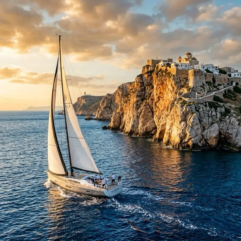
Days 12–13: Folegandros, The underrated gem. Anchor in Vathi or Angali bay while the village of Chora perches 300 metres above you on the clifftop. Timing: arrive before 13:00 as the Meltemi accelerates into the northern bay.
Day 14: Return passage, Motorsail north in the pre-dawn calm to pick up the first thermal breeze. Target Sifnos as a waypoint, then Kythnos, then the return to Athens.
Anchorage Intelligence: The Islands in Detail
Paros, The Navigator's Preferred Base
Paros offers more anchorages than any other island in the central Cyclades:
- Naoussa Bay (N entrance): Best in W–SW. Holding excellent in sand. Anchor in 4–6m. Beware the ferry wake from the small commercial pier.
- Alyki Bay (S coast): Natural protection from N and NW. Taverna on the beach. Good holding.
- Logaras (SE): Exposed to SE winds. Use only in stable NW conditions.
- Santa Maria (NE): Kitesurfer's paradise. Anchor south of the surf zone.
Naxos, The Meltemi Refuge
When a force 6–7 Meltemi is pinning you down, Naxos Town is where you want to be:
- Town Harbour: Mostly for ferries, but a small quay allows stern-to berthing. Check with the port authority.
- Anchor SSW of the harbour in 4–7m over sand. Good holding. The famous Portara (temple gateway) watches over you from the headland.
- Agios Georgios Bay: Flat-water swimming in the morning. Exposed to ferry wakes from 06:00 onward.
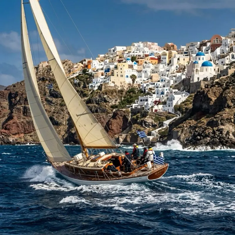
Santorini (Thira), Beautiful and Challenging
Be honest about Santorini before you go:
The caldera anchorage (inside the volcanic crater) is spectacular but difficult:
- Depths: 20–40m in most of the caldera, you need 100m+ of chain for a proper scope
- Holding: Variable. The dark volcanic bottom offers inconsistent holding
- Swell: Can enter from the open southern end in S weather
- Ferries and cruise ships: Constant traffic. Never leave the boat unattended at anchor here
- The tender trip to the steps (Fira or Oia) in a Meltemi chop is character-building
Alternative: Anchor in Vlychada on the south coast, a structured marina in a dramatic sculpted landscape of volcanic pumice cliffs. Far calmer, easier logistics, and equally Santorinian in atmosphere.
Milos, The Secret Masterpiece
Milos gets a fraction of Santorini's visitors but arguably more dramatic geology:
- Adamas harbour: Full marina services, good fuel dock, excellent fish market
- Kleftiko: Only accessible by boat. Anchor in the extraordinary white cave formation on the SW coast. Completely calm in NW winds (protected by the headland)
- Sarakiniko: The famous white lunar landscape on the north coast, anchor in the small bay and swim to the rocks
- Fyropotamos: Quiet, colourful fishing village anchorage. Empty in all but peak season
Safety and Seamanship in the Cyclades
Rescue and Assistance
- Greek Coast Guard (Limeniko Soma): Channel 16 VHF at all times. Highly responsive.
- Emergency: 112 (pan-European) works across the islands
- MRCC Athens: +30 210 4191000, Maritime Rescue Coordination Centre
- Sea rescue distances: You are rarely more than 20nm from a port in the Cyclades, this is a factor in your safety margin calculations
Weather Resources
| Resource | Access | Best For |
|---|
| POSEIDON (Greek Met Service) | poseidon.hcmr.gr | Official Greek marine forecasts |
| Windy.com | windy.com | Visual wind modelling, Meltemi tracking |
| PredictWind | predictwind.com | GRIB file routing (premium) |
| Weather Fax (WXFAX) | SSB radio 4/8/12MHz | Synoptic charts, passage planning |
| Navtex | Navtex receiver | Local coastal warnings, gale alerts |
Your Crew Briefing Checklist
Before departing any anchorage in the Cyclades:
- Wind forecast for the next 24 hours (not just the next 6)
- Passage distance and duration at your expected VMG
- Swell height and period at your destination anchorage
- Lee shore risk at your destination if the wind backs
- Alternative anchorage if your primary is untenable on arrival
- Fuel status relative to the next fuel dock
- Crew condition, fatigue management is seamanship
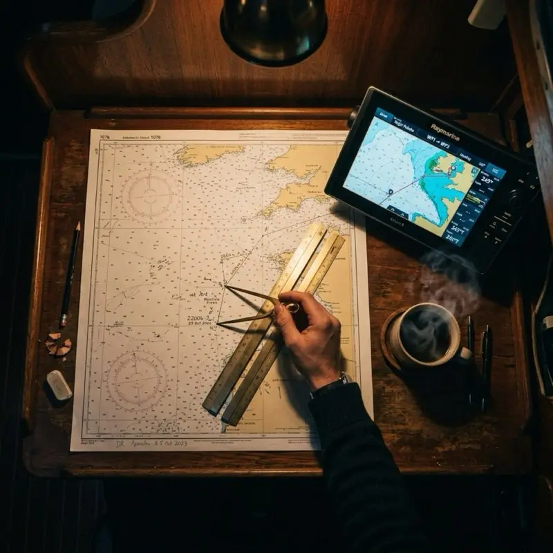
Navigation Equipment and Chart Recommendations
Paper Charts (Essential, Not Optional)
Despite GPS, paper charts saved lives in the Cyclades every season when electronics fail, batteries die, or a chartplotter mount snaps under vibration. Carry:
- Imray Charts: Series G for the Cyclades. Published with anchorage plans, updated regularly.
- Admiralty Charts: 1531 (Aegean Sea, Northern Part), 1532 (Aegean Sea, Southern Part)
- Greek Hydrographic Service charts: The most detailed and current for inshore work. Available in Piraeus and Syros
Electronic Navigation
- Navionics (Boating app): Best vector chart coverage for the Cyclades. Use the SonarChart overlay for depth detail in anchorages
- OpenCPN with CM93 charts: Effective offline chartplotter software for iPad/tablet
- AIS transceiver: Mandatory for identifying the large fast ferries (Hellenic Seaways, Blue Star) that traverse the Cyclades at 25+ knots, often at night
Anchoring Gear
The Cyclades demands proper ground tackle:
- Anchor: Delta or Rocna in 20kg+ for a 40ft yacht. The volcanic and weed-covered bottoms in some bays punish light anchors
- Chain: Minimum 50m of 10mm calibrated chain. 70m is better
- Snubber: Always. The surge and wakes in Cyclades anchorages load the windlass brutally without one
- Stern anchor or lines: Essential for Mediterranean mooring to quays. Have it rigged and ready before you approach
The Cultural Navigation: Reading the Islands
The Cyclades rewards the sailor who looks beyond the anchorage. A few non-nautical tips from experience:
Water is precious. Every island manages freshwater differently. Naxos is relatively water-rich. Folegandros and Ios are not. Fill your tanks whenever a water point is available, do not assume the next island will have an easy supply.
Respect the fishing boats. The colourful wooden caique fishing boats at anchor or mooring in a bay have right of way in spirit, even if not in law. Give them wide berth. The fishermen know the underwater rocks that do not appear on any chart.
The afternoon siesta is real. Between 14:00 and 17:00, most tavernas are closed, most shops are shut, and most harbourmasters are asleep. Arrive, anchor, swim, and wait. The evening comes alive around 20:00 and the best meals start at 21:30.
Octopus on the line. If you see octopus hanging to dry on a washing line outside a taverna, it means the place fishes locally and takes its food seriously. Eat there.
A Final Word: What the Cyclades Teach You
The best navigation instructors are not people. They are places.
The Cyclades will teach you patience, because the Meltemi will not negotiate. It will teach you observation, because the sky here gives you information that no weather app fully captures. It will teach you humility, because the channel between Paros and Naxos in a Force 7 is not the place to discover that you overestimated your boat or your crew.
And then, on the morning when the Meltemi lies down for a day and the sea turns the colour of old turquoise glass and the outline of Delos rises off your bow and the only sound is the bow wave and a distant bell, it will teach you why mariners have been coming back to these waters for three thousand years.
The Cyclades does not just test your seamanship. It extends it.